UC Geographers Develop a System to Track the Dynamics of Drought
University of Cincinnati researchers are at work tracking drought patterns across the United States. Qiusheng Wu, a doctoral student and research assistant for the UC Department of Geography, and Hongxing Liu, a UC professor and head of the Department of Geography, will present details this week at the annual meeting of the Association of American Geographers (AAG) in Tampa, Fla.
To trace the dynamics around agricultural drought, the UC researchers implemented an Event-based Spatial-Temporal Data Model (ESTDM) to detect, track and monitor conditions. The framework organizes data into objects, sequences, processes and events.
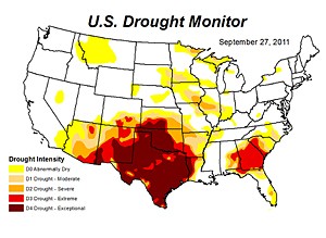
The data was collected from the European Space Agencys (ESA) Soil Moisture and Ocean Salinity (SMOS) satellite, which was the first of its kind dedicated to measure moisture near the surface of the soil. The study focused on four years of data (2010-2014), which included the devastating Texas drought in 2011 and the 2014 California drought.
The satellite uses an L-band (1.4 Ghz) passive microwave radiometer to analyze the spatial and temporal variations of soil moisture and ocean salinity. Recent studies have shown that many historical drought events in the U.S. are closely related to La Niña, a phenomenon known for its periodic cooling of sea surface temperatures in the tropical Pacific Ocean. So in addition to measuring soil moisture for drought monitoring, it is also important to measure ocean salinity, explains Wu.

drought graphic
The satellite can penetrate the Earths surface up to 5 centimeters, providing a soil variable for each pixel, which represents 25 kilometers. The satellites data collection occurred over a three-day rotation.
The researchers were examining patterns of spreading drought to develop predictions for future drought events.
Soil moisture is defined as the ratio between volume of water and volume of soil holding the water, which is expressed in percentages, so high soil moisture indicates wet while low soil moisture indicates dry.
By studying the soil moisture data from the satellite, we can see where the droughts begin and end, and what might indicate patterns of how it can spread over one large area. The pattern might be used to predict the drought in another location, so that those areas could take precautions to avoid the impact of an oncoming drought, says Wu.
The Intergovernmental Panel on Climate Change (IPCC) known as the leading international organization for the assessment of climate change predicted in 2012 that droughts would intensify in some seasons and in many regions worldwide in the future due to reduced precipitation and/or increased evapotranspiration.
Drought ranks among the most costly of all natural disasters. It has wide-ranging impacts on many sectors of society, affecting agriculture, economics, ecosystems services, energy, human health, recreation and water resources. By predicting the timing, severity and movement of drought events, we can provide fundamental information for planning and management in developing a response plan, says Wu.
Future research will involve data gathered from a satellite that NASA is launching toward the end of the year, the Soil Moisture Active Passive (SMAP) satellite. The SMAP satellite integrates an L-band radar (1.26 GHz) and an L-band (1.41 GHz) radiometer as a single observation system combining the relative strengths of active and passive remote sensing for enhances soil moisture mapping. The combined radar-radiometer-based soil moisture product will be generated at about an intermediate 9-km resolution with three-day global revisit frequency. Wu says the accuracy, resolution and global coverage of SMAP soil moisture and freeze/thaw measurements would be invaluable across many science and applications disciplines including hydrology, climate and carbon cycle, and the meteorological, environmental and ecology applications communities.
The Association of American Geographers (AAG) is a nonprofit scientific and educational society that is dedicated to the advancement of geography. The meeting will feature more than 4,500 presentations, posters, workshops and field trips by leading scholars, experts and researchers. The AAG annual meeting has been held every year since the association's founding in 1904.
Related Stories
Grad school requirements: What you need to apply and get accepted
Applying to grad school? Learn about key admission requirements, including GPA, test scores, letters of recommendation, and deadlines, to submit a strong application with confidence. Get expert tips and a checklist to stay on track.
UC Journalism to host Hall of Fame, Young Alumni Awards
Event: April 24, 2025 6:00 PM
The College of Arts and Sciences’ journalism department will host the Hall of Fame and Young Alumni Awards to celebrate the achievements and accomplishments of its graduates. Induction into the UC Journalism Hall of Fame is a special honor reserved for UC alumni who have excelled in the profession of journalism and media, or individuals who have made a significant contribution to journalism at UC.
Bradford pear trees look pretty, smell awful. Why are they...
April 2, 2025
WLWT talks to UC biology Professor Theresa Culley about Ohio's ban on the sale or planting of nonnative and invasive pear trees. The trees are showing up in many parks and wild areas where they are crowding out native species.
