Geography Research Could Improve the Effectiveness of Hospital Patient Transport Services

University of Cincinnati research is offering hospitals and trauma centers a unique, accurate and scientific approach to making decisions about transporting critical-care patients by air or by ambulance.
A presentation this week at the annual meeting of the Association of American Geographers (AAG) in Tampa, Fla., highlights the research of Michael Widener, a UC assistant professor of geography, along with Zac Ginsberg, MD, Maryland Shock Trauma Center; Samuel Galvagno Jr., assistant professor, Divisions of Trauma Anesthesiology and Adult Critical Care Medicine, Maryland Shock Trauma Center; and Daniel Schlieth, a UC graduate student.
The research uses analysis by Geographic Information Systems (GIS) technology to provide information on whether patient transport would be more successful by ambulance or medical helicopter in terms of cost as well as patient care. Early results indicate GIS technology is both accurate and successful in providing estimated transport times to trauma centers.
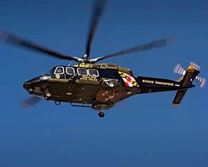
The study analyzes patient transport data from the Maryland Medevac Helicopter Program, focusing on travel time equal to or less than 60 minutes, the so-called golden hour of getting critical-care patients to treatment. Recognized as a national model, the Maryland Medevac Helicopter Program is considered to be one of the largest and most sophisticated air-medical transport systems in the country.
Launched in 1970, the elite system in Maryland is taxpayer funded and operated by state police, with the philosophy that a medical helicopter can transport anyone in the state within the hour. The system is coordinated by the Maryland Institute for Emergency Medical Services System.
However, the system carries a considerable price tag for its operation and maintenance. One medical trip costs thousands of dollars in operating costs. In 2012, Maryland
Governor Martin OMalley announced a $121.7 million
contract for 10 new state-of-the-art helicopters to replace the states 11 helicopters, 10 of which were more than 20 years old.
State protocols for operation were updated beginning in 2004 and more policy changes followed a medical helicopter crash in 2008 that killed two state police, a medical technician and a patient. Another patient survived that accident, but was left with severe injuries. The helicopter was en route to the hospital in foggy weather, after picking up two people injured in a traffic accident.
In applying the GIS technology to factor ambulance versus medical helicopter response times, the researchers examined more than 10 years of medical helicopter transports in a five county area surrounding Frederick County, Maryland, over 2000-2011. The data involved 2,200 medical cases.
The technology computed the time of air transport versus ground transport, accounting for distance (and not just a straight line) for ground travel, as well as speed limits estimating that ambulances would travel 10 miles per hour over the posted speed limit. We could also account for slower traffic in our calculations, such as traffic jams or other delays, but we assume that such slowdowns are not a factor, since ambulances can use the shoulder, and traffic will usually clear a path for EMS vehicles, says Widener.
Based on the analyses of the medical cases in the study, the researchers found that 31 percent of the trauma cases transported by air could have also been transported by ambulance within the golden hour of trauma treatment, saving taxpayers thousands of dollars.
Once a trauma center has decided it needs to accept a patient, the question becomes, how can you most safely get them there? So what GIS, when applied to this medical and clinical decision-making moment allows, is the accurate assessment of the time costs, and we want to take this research into examining how to benefit the patient the most, says Ginsberg. We must still take into account the severity of the patient, but from this research, we have the answer to a question that has not been able to be answered accurately: From where you are, how long is it going to take to get to the trauma center?
As the system becomes more motivated to fly fewer patients not just for cost but also for safety we think GIS is going to play a key role. The technology and analytical methods that Michael has developed for this are going to play a key role in policy decisions and allocation of what is an expensive and limited resource, says Galvagno.
Ginsberg says that future research might also involve looking into how policy changes and hospital closures changed patterns of utilizing helicopters.
Widener says that GIS has been in existence since the 1960s, and was first developed in Canada to manage land inventory. The popularity of the technology didnt increase until the rise of personal computers in the late 20th century. Widener says GIS now has a wide range of applications from business operations to transportation, conservation and agriculture, urban planning and more areas.
The
Association of American Geographers (AAG)
is a nonprofit scientific and educational society that is dedicated to the advancement of geography. The meeting will feature more than 4,500 presentations, posters, workshops and field trips by leading scholars, experts and researchers. The AAG annual meeting has been held every year since the association's founding in 1904.
Related Stories
Creating a stronger community on and off campus
April 23, 2025
UC student leaders discuss the need for better student-neighborhood relations and a desire to build a better community on campus. Student Body President Joshua Copley and Student Body Vice President Wilaini Alicea are being their term with UC Student Government.
UC celebrates Earth Day 2025 with award-winning publication
April 21, 2025
Earth Day celebrates its 25th anniversary this year. Since its inception, Earth Day has gone global, and with its adoption have come federal intuitions such as the EPA (Environmental Protection Agency) and policies familiar to most: the Clean Air, Clean Water and Endangered Species acts. This year, UC’s College of Arts and Sciences has reason to celebrate as well. It’s a regional win, capturing the reformation of Fernald, a former nuclear production facility located in northwest Cincinnati. Professor and environmental historian Casey Huegel has received numerous awards for his book, “Cleaning Up the Bomb Factory: Grassroots Activism and Nuclear Waste in the Midwest,” (Weyerhaeuser Environmental Books, 2024).
UC student receives renowned Truman Scholarship
April 18, 2025
Harshman Sihra, a reproductive health advocate planning a future as an OBGYN and public health policymaker, is now the third University of Cincinnati student to win the Harry S. Truman Scholarship.